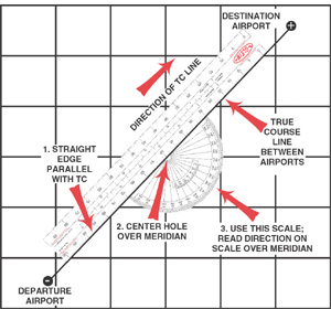
Use your plotter to determine the true course (TC), the total distance of your flight, and
the distance between each checkpoint.
Place the small hole in the center of the protractor section over a meridian (line of
longitude), and then align either the bottom or top edge of the ruler section with your course
line, as shown below.
In the illustration above, the TC, which is read on the scale over the meridian, is
042°. The reciprocal (return) course is 222°. Make sure that you use the proper scale for
your direction of flight.
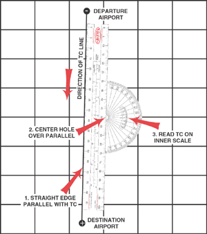
Meridians are not parallel lines. They converge at the poles. Therefore, course
measurements should be made near the midpoint of each segment.
If your course is nearly north or south and does not cross a meridian, place the hole of
your plotter over a parallel (line of latitude), and use the inner scale as shown below.
Measure the total distance of the course, as well as the distance between checkpoints with
the ruler section.
Use the scale that is appropriate to your chart (Sectional, Terminal Area Chart, or
World Aeronautical Chart).
You should generally use the nautical mile scale for most operations.