
Last week’s blog dissected what thunderstorms are and their potential hazards. This week, we review the importance of obtaining weather information and why we should remain clear of thunderstorms.
A Case Study
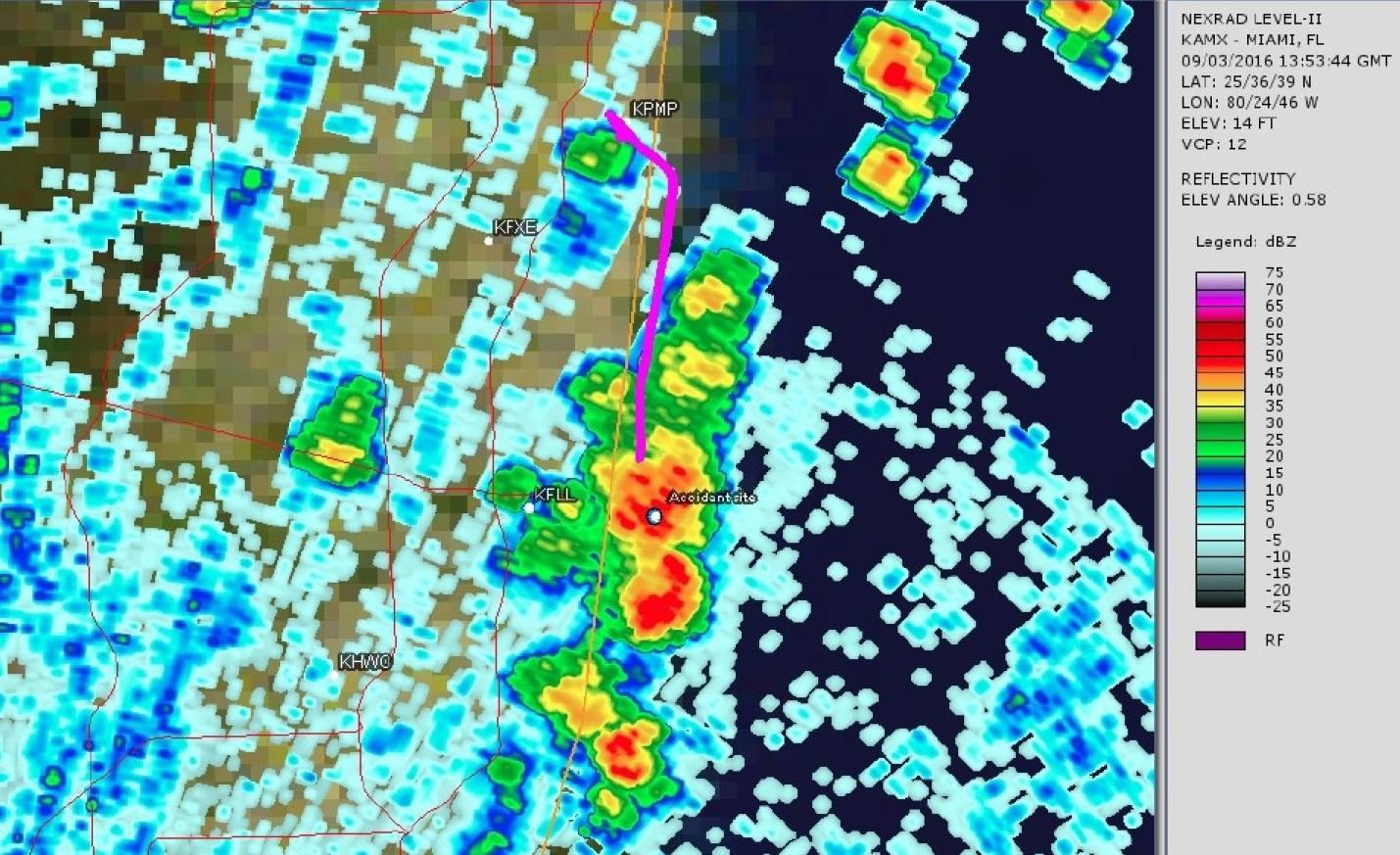
[The following are excerpts from Accident Number: ERA16FA309]
On September 3, 2016, about 0950 eastern daylight time, a Cessna 172N, N6091E, was destroyed when it impacted the Atlantic Ocean while maneuvering near Hollywood, Florida. The private pilot and the pilot-rated passenger were fatally injured. Visual meteorological conditions prevailed, and no flight plan was filed for the personal flight conducted under the provisions of 14 Code of Federal Regulations Part 91. The airplane departed from Pompano Beach Airpark (PMP), Pompano Beach, Florida, at 0932 and was destined for Ocean Reef Club Airport (07FA), Key Largo, Florida. The pilot did not receive a weather briefing before beginning the cross-country flight.
While flying south along the shoreline, the pilot contacted the air traffic control tower at the Fort Lauderdale/Hollywood International Airport (FLL) and requested to fly through the tower’s airspace below 500 ft above ground level. The air traffic controller approved the request but advised the pilot of “heavy precipitation at the 12 o’clock position and 4 miles ahead” and stated, “you should turn left and go off shore 3 miles to avoid the thunderstorm.” The pilot acknowledged the communication, and 3 minutes later, the pilot reported, “I am turning back to the north.” The air traffic controller approved the turn, and no further communications were received from the airplane. It is likely that the pilot lost control of the airplane when it encountered strong downdrafts and heavy rain associated with the thunderstorm.
Review of radar and GPS data that were downloaded from a portable GPS receiver, revealed that the pilot did not turn left and fly offshore as the air traffic controller advised. The data showed that the airplane instead maintained a southerly heading. The airplanes final GPS-derived position was recorded at 0950, with the airplane at a GPS altitude of 440 feet, a groundspeed of 85 knots, and tracking southbound. About 0951, when the pilot advised the controller that he was turning around and heading north, and when the airplane was about 3 miles east of FLL, radar contact was lost at a reported altitude of 200 feet with the airplane tracking eastbound. A search was initiated, and the airplane wreckage was located about 2 miles east of the shoreline submerged in the Atlantic Ocean.
The National Transportation Safety Board determines the probable cause(s) of this accident to be: The pilot’s inadequate preflight and in-flight weather planning, which resulted in continued flight into a thunderstorm and a subsequent loss of airplane control.
Get a Weather Briefing
14 CFR 91.103 requires every pilot to become familiar with all available information concerning the respective flight. Flight Service is responsible for providing official weather briefings to pilots and can be found online at www.1800WXBrief.com or by calling 1-800-WX-BRIEF.
Recall your N-W-KRAFT
N – NOTAMs
W – Weather
K – Known ATC delays
R – Runway lengths
A – Alternates available
F – Fuel requirements
T – Takeoff and landing distances
Using Aviation Digital Data Service (ADDS)
ADDS is maintained by the National Weather Service, and it provides information on weather conditions through observations, forecasts, PIREPS, and radar and satellite images. Though all the information on ADDS is highly beneficial and a key component to thorough flight planning, you will still be required to obtain a Flight Service briefing. ADDS does not provide NOTAMs or other critical information for flight.
When it comes to thunderstorms, radar (Radio Detection And Ranging) provides pilots with a picture of precipitation intensity that identifies and determines thunderstorm structure and location. However, any “current” radar image on ADDS is still minutes old because it requires the radar station to beam out and receive return radio waves and to measure the change in the wave’s shape, position, and form. The calculation process can take a matter of minutes before the information displays on a radar screen. Whether on the ground or airborne in areas of known thunderstorm activity, the representation of thunderstorms shows you where they were, not where they are currently. It can be hard to stay ahead of the aircraft when you may be this far behind the weather.
Datalink Weather
There are multiple products that provide “current” weather to pilots. From Sirius XM through to ADS-B, pilots have access to valuable weather depiction tools. Most of the datalink products are subscription based though datalink weather delivered through Flight Information Services-Broadcast is free and largely comparable. Depending upon provider selection, electronic flight bag (EFB), or electronic flight instrument system (EFIS) suite, many of the user interfaces and displays will vary. This does not imply that one is better than the other, but rather, depending on your preference, you may find one type of datalink system better suited to your use.
Similar to the constraints of ADDS, the datalink weather is also minutes old. Typically, weather information is displayed with a time stamp so pilots have an understanding of when the weather occurred. Have a look at the typical product update and transmission intervals over universal access transceiver here.
Datalink Weather: Technology as a Tool
Even though FIS-B product availability will vary based on individual ADS-B avionics capability (always refer to your avionics manufacturer for details), the true time, intensity, and location of the thunderstorm activity is probably 3 to 5 minutes older than the time stamp. These systems are advisory in nature and are intended as a resource to inform situational awareness and enhance safe decision making on the flight deck.
As described, though highly useful, they lack the updating capability and sufficient resolution to be used in tactical aerial maneuvering around localized weather phenomena.
Remember, the FAA’s best practice is to remain at least 5 NM, if not 10 NM, from any visual storm. If the storm is growing fast, increase distance to at least 20 NM distance. Hail and violent turbulence can be encountered anywhere within 20 miles of very strong thunderstorms.
Review our Summer Flying Series: Thunderstorms Part 1, where we review the recommended course of action for flight proximate to thunderstorm activity.
IMC and Embedded Thunderstorms
Using ATC’s radar guidance and datalink weather while under IMC to navigate around thunderstorms has far less margin for error than many think. Why? In meteorological conditions that are conducive to forming thunderstorms, they can grow quickly and unpredictably. In the minutes between when the storms are located by radar and when viewable on screen, the storms could have moved miles.
Onboard Radar
Radar is a spectacular tool to remain clear of thunderstorms. One of the clear benefits of onboard radar is that the time delay is far less pronounced than when using datalink weather. Pilots can increase the range of the radar from near to far so they can make the best plan to avoid weather ahead. Although onboard radar is superb at helping pilots avoid thunderstorms, they should not be shy to get assistance from ATC and surrounding aircraft via pilot reports. Finally, if you are lucky enough to fly an aircraft with onboard radar, don’t forget to have it on when flying at night.
Try to Stay VMC Even If You Filed IFR
Unless you have onboard radar, the risk adverse personal minimums is to try to stay VMC unless you know the conditions aren’t conducive for thunderstorms to develop. Try to get between cloud layers or either get on top or below the clouds. This allows you to visually confirm what you are seeing with your datalink weather or onboard radar.
What Should I Have Learned?
Thunderstorms form with the three ingredients of moisture, instability, and an upward lifting action. Updrafts start the process of forming cumulus clouds and are due to surface heating; converging winds; sloping terrain frontal surface; and local winds from lakes, valleys, sea, etc. Eventually, a thunderstorm forms from a cumulus cloud. They can be between 5 and 30 miles in diameter and as high as 65,000 feet. Some of the greatest hazards from thunderstorms are turbulence, hail, and lightning. Compounded with these hazards is that they can form and grow quickly. Radar, flight service weather briefings, and in-flight datalink weather can help pilots understand where thunderstorms are and how they may impact the flight plan.
These resources need to be used while being mindful of the air mission as thunderstorms can move quickly and the data being disseminated to pilots may be minutes old.
By adhering to a personal minimums checklist and applying solid risk management strategies (which may include VMC flight only!), pilots ensure the safety of themselves and their passengers.
We can, over time, build a better working knowledge of cellular activity and constantly generate alternate plans as part of of our thorough preflight action. We can work toward a better application of the weather information received, ensuring accuracy and maintaining those safety margins of at least 5 miles, if not 10 or more miles, from thunderstorms that allow us to complete our flight missions safely.
The “Thunderstorm Encounters” below were included in NTSB Final Report for accident number ERA16FA309. The information is highly informative and useful for pilots, so it is included below. Enjoy the summer and fly safe!
NTSB Accident Report: Thunderstorm Encounters
[Continued from Accident Number: ERA16FA309]
Even when pilots are flying under instrument flight rules (IFR) and in contact with air traffic controllers, accidents can still occur due to in-flight weather because the pilots are either not advised of the severe weather ahead or are given incorrect information. Often, pilots have readily available alternatives that, if utilized, could prevent an accident.
Severe weather avoidance is primarily the pilot’s responsibility. The primary job of the controllers is to keep IFR aircraft separated. When their workload permits, controllers are also required to provide additional services such as weather advisories, and, upon pilot request, suggested headings to avoid radar-displayed precipitation. The proper use of air traffic control (ATC) weather advisory services may be critical to safety when operating near areas of convective activity. Pay attention to weather alerts broadcast by ATC, especially SIGMETS and Center Weather Advisories, and obtain further details from HIWAS or Flight Watch if the advisory is anywhere along or near your route. Flight Watch can also supply “big picture” weather information beyond what ATC may have time to provide to you.
The precipitation detection and display capabilities of ATC facilities vary from poor to excellent. Some have older analog radar systems that depict precipitation as a monochrome reflective area with no associated intensity values, while others have fully digitized radar systems with color displays showing both the extent and intensity of precipitation. Approach control radar systems provide near-real-time weather depiction. En route centers receive weather radar information from National Weather Service NEXRAD sites that refresh the color precipitation data on ATC displays every 4 to 5 minutes. Be aware that en route weather displays may be a few minutes behind the storm and allow extra distance from reported intense precipitation, especially in front of fast-moving convective activity. Be especially diligent about asking for updates after being transferred from one ATC facility to another. The new controller may have better equipment or be using a different radar site and have an entirely different picture of what lies ahead.
ATC radar systems depict only precipitation. Controllers cannot use radar to warn of turbulence, icing, freezing rain, or other hazards to flight. However, the presence of substantial precipitation implies the existence of thunderstorm hazards such as severe turbulence and hail. ATC weather advisories should include the location, extent, and intensity of radar-observed precipitation. The descriptive words for intensity were recently changed to ensure consistency across all ATC facilities. The old level 1 is now “light”; level 2 is “moderate”; levels 3 and 4 are described as “heavy”; and levels 5 and 6 are described as “extreme.” If precipitation is described to you without any reference to intensity, ask for the information so you can make a good decision about how to proceed. Not all ATC radar systems can provide intensity information. In such situations, you should be told “intensity unknown.”
Become familiar with the various on-board weather avoidance technologies available, including datalinked onboard NEXRAD weather services, and consider whether the additional information will help you to avoid encounters with severe weather.
Sometimes the controller may be uncertain about whether a pilot is visually avoiding severe weather areas or needs radar weather assistance. The controller may think the pilot is able to see what is ahead, and the pilot may think the controller is watching out for him. It is especially important that you advise controllers if your flight conditions change from visual to instrument, and that when operating in instrument conditions you regularly request updated information on radar-depicted weather ahead of your aircraft.
Ambiguous use of the term “when able” has also led to confusion. Some controllers use “Cleared direct xxx when able” to mean “when weather permits you to turn safely on course,” while pilots may understand such an instruction to mean “Go direct to xxx as soon as you can navigate there.” In some cases, this ambiguity has apparently led pilots receiving ATC weather avoidance assistance to conclude that it was safe to turn direct to the specified fix, resulting in subsequent entry into thunderstorms. If you have any uncertainty about whether a course change will keep you clear of convective weather, ASK!
You can help controllers and other pilots by giving pilot reports. Controllers use them to confirm their radar weather depiction, and to obtain details such as cloud tops or the existence of icing that may not be available through any other source. Pilot reports also help controllers advise other aircraft about what to expect and what to avoid.
The safest plan when avoiding severe weather activity is to entirely avoid the affected area or land and wait for it to pass. Make decisions about weather deviations as far in advance as possible. Controllers will have more time to respond to your needs, perform any necessary coordination, and provide you with the information you require to conduct a safe flight.