
 Recent years have seen a huge boom in Unmanned Aircraft Systems/Vehicles (UAS/UAV), colloquially referred to as drones, in both the recreational and commercial sectors. While hobbyists and drone enthusiasts enjoy recreational flight under 14 CFR Part 101, the moment a flight serves a commercial or non-recreational purpose it becomes subject to Part 107 regulations. These regulations, written specifically for small Unmanned Aircraft Systems (sUAS), regulate the use of drones for commercial purposes and establish requirements for remote pilot certificates.
Certificated drone operators flying for commercial purposes are required to obtain authorization from the FAA prior to flying in controlled airspace. Operators should use reliable sources of information, such as current aeronautical charts and the FAA’s B4UFLY app, to determine if a planned flight will take place in controlled airspace. Outside of controlled airspace, 14 CFR 107 allows commercial drones to fly up to 400 feet. A common restriction inside controlled airspace is a reduction of the authorized maximum altitude due to the proximity of lower flying manned aircraft.
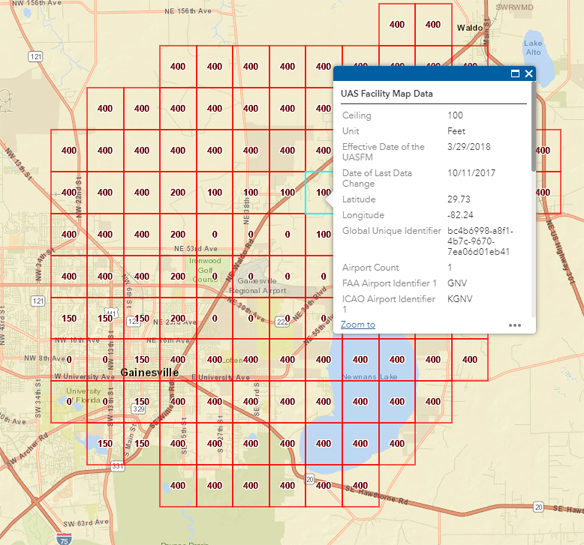
The process of obtaining approval to operate in controlled airspace can be streamlined if you know in advance which restrictions are likely to be placed on your flight. If you haven’t yet, you should familiarize yourself with the FAA UAS data maps. The maps are a simple, yet informative means to quickly visualize the default altitude limitations within controlled airspace sectors. As you can see on the facility map surrounding Gainesville Regional Airport (KGNV), sUAS flights are restricted to zero feet in the airspace immediately surrounding the airport. Gradually, the altitude limitations are eased farther from the airport. The maximum altitude in each sector is dependent on runway layouts, approaches into the airport, and other local considerations.
It is important to note that the facility maps do not provide authorization to fly in controlled airspace. These maps just show the limitations that you are likely to encounter and should be used as a guideline when submitting an airspace authorization request. Such requests should not be made to the local Air Traffic Control (ATC) facility. The FAA has instructed ATC to direct verbal requests to the FAA DroneZone portal to ensure remote pilots are properly registered and eligible for authorization. This comes with the benefit of reduced distraction for controllers whose time is better spent focusing on active air traffic.
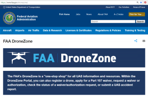 The FAA refers to the DroneZone as “a one-stop shop for all UAS information and resources.” There you can find general information about becoming a certificated drone pilot. Most importantly, it is where remote pilots can request waivers or authorization and check on the status of those requests. DroneZone helped streamline the waiver application process, but as the agency revealed at the FAA UAS Symposium in March, 2018, while they have processed over 32,000 requests, at least 12,000 requests are still pending. With such a huge backlog and a team of only 15 officials to handle incoming requests, the average application takes 90 days or more to process before pilots are alerted as to whether or not their request has been granted.
The process does not accommodate a remote pilot-in-command’s client, who often has a much shorter turnaround time than the typical 90 days required to process a request. Additionally, complex requests that require more than one waiver or authorization take even longer to process. Unfortunately for the FAA and public safety in general, when faced with a choice between a lengthy application process or momentarily breaking the rules, a not-insignificant number of remote pilots would rather risk taking their small drone into controlled airspace for a few minutes.
 Enter LAANC, the Low Altitude Authorization and Notification Capability system. The system, which falls under the FAA UAS Data Exchange, allows commercial remote pilots to submit airspace authorization requests in their area with just a few clicks. This process takes mere seconds, compared to the usual 90-plus days. According to the FAA, LAANC “provides access to controlled airspace near airports through near real-time processing of airspace authorizations below approved altitudes in controlled airspace.” As a result, remote pilots can secure clients and fulfill requests because they can provide service in a timely manner. More importantly, companies interested in deploying drones can do so safely and legally without the lengthy waiting process.
Phoenix, Arizona remote pilot Chris Tinard said he’s used LAANC many times. “It’s great.” He was able to obtain authorization either instantly or in minutes for downtown Phoenix at altitudes of up to 100 feet. He was also able to get a different authorization up to 400 feet by Cesar Chavez High School. “I use Skyward, and it takes 2 minutes to fill out the online form.” Tinard has expressed his excitement to know that nationwide deployment is expected by the end of the summer. “Airspace authorization solves over 90% of job requests I get, so to have an instant response gives me the ability to tell my clients with confidence that I can do the job.”
The LAANC system is rolling out in waves across the United States. The first wave rolled out on April 30th, 2018, in the South Central region. On May 24th, 2018, Wave 2 will expand into the Western North USA. By the end of September, nearly 300 ATC facilities across the country will accommodate LAANC authorization, providing coverage for about 500 airports and their controlled airspace.

How to Use LAANC
To obtain authorization using LAANC, you’ll actually be submitting your request to a third-party company that has contracted with the FAA to provide LAANC services. These companies verify that requests are compliant with flight restrictions in effect, NOTAMs, and other data before granting authorization. Only four companies have been approved so far, but as the system rolls out and usage becomes more commonplace, expect to see more companies added to the list. A list of currently approved LAANC service suppliers can be found on the UAS Data Exchange website.
The FAA anticipates that the improved flexibility in operation planning will reduce UAS controlled airspace non-compliance by 30%. We appreciate that the FAA has responded to a problem plaguing many remote pilots in a constructive way. By creating a more efficient process for obtaining waivers or authorizations, the FAA has encouraged remote pilots to take the proper steps toward increasing safety in the national airspace system.
 Want to Get Paid to Fly Drones?
Turn your drone-flying hobby into a career by flying small Unmanned Aerial Systems (sUAS). The Gleim FAA Test Prep Online has helped thousands of pilots prepare for the Remote Pilot–sUAS written exam.
About Gleim Aviation
Since 1980, the Gleim Aviation team of pilots, instructors, writers, designers, and programmers has helped aviators pass millions of FAA knowledge and practical tests using the unique Gleim Knowledge Transfer System. Gleim is an environmentally-friendly company headquartered in Gainesville, FL.